mew-ti App Introduction
Introduction
Mew - ti is a remarkable software application that has been designed to make traveling on the Shuto Expressway a more efficient and stress - free experience. With the ever - increasing traffic congestion and the need for accurate route guidance, Mew - ti steps in as a reliable solution. It is specifically tailored for use on the Metropolitan Expressway and is optimized for Android devices running OS 6.0 or higher.
The Core Features of Mew - ti
Real - Time Route Search
One of the most important features of Mew - ti is its real - time route search. Using GPS technology, it can instantly calculate the shortest path from your current location to your desired destination. This not only saves time but also helps in avoiding traffic - clogged routes. The estimated travel time provided is highly accurate, taking into account the current traffic conditions. For example, if there is a sudden traffic jam on a particular stretch of the expressway, Mew - ti will quickly recalculate the route to ensure you reach your destination as soon as possible.
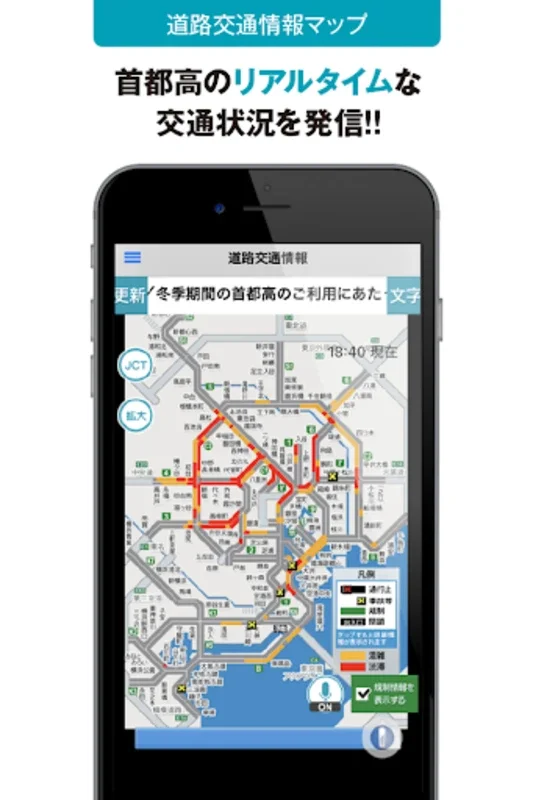
Comprehensive Traffic Congestion Information
Mew - ti offers a detailed display of traffic congestion information. This information is updated every five minutes, which means you get the most up - to - date data on the road conditions. It provides insights into the traffic situation over the past two hours, allowing you to make informed decisions about your journey. For instance, if you see that a particular area has been congested for the past hour, you can choose an alternative route even before you reach that area.
Anticipated Travel Duration from Multiple Points
The system is intelligent enough to provide the anticipated travel duration from various expressway entrances, parking areas, and junctions to your destination. This is based on your current GPS - detected location. So, whether you are starting from a parking area or an expressway entrance, Mew - ti will give you an accurate estimate of how long it will take to reach your destination. This feature is extremely useful for planning your journey in advance and making sure you reach your destination on time.
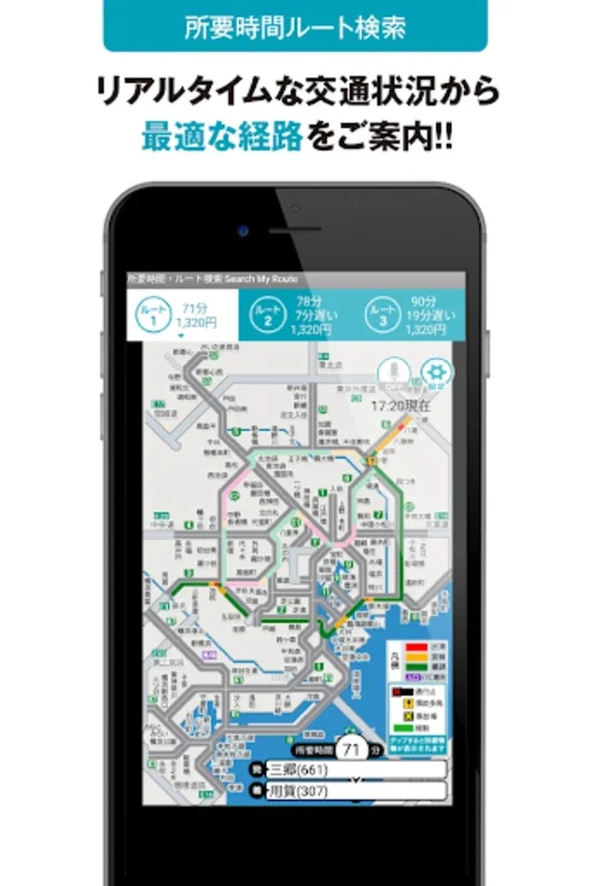
Map - Based Route Comparison
All routes can be displayed on a map, which enables you to compare travel times easily. This visual representation of the routes helps in making a more informed decision. For example, you can see which route has more traffic - free stretches and which one might be shorter in terms of distance but has more potential for traffic congestion. This way, you can choose the route that best suits your needs, whether it is to reach your destination quickly or to have a more relaxed drive.
Additional Useful Features
Crowdness Level Calendar
Mew - ti comes with a crowdness level calendar. This presents event - regulated traffic data from the corresponding dates of the previous year. By looking at this calendar, you can anticipate traffic levels on certain days. For example, if there was a major event on a particular date last year that caused traffic congestion, you can be prepared for similar traffic conditions this year. This helps in planning your trips well in advance and avoiding potential traffic - related delays.
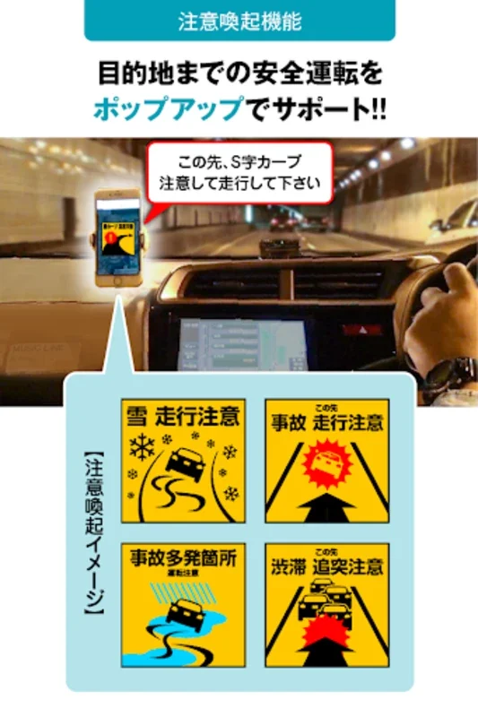
Accident - Prone Spot Map
Safety is a top priority when traveling, and Mew - ti addresses this with its accident - prone spot map. This map identifies the frequent accident locations along your route. By being aware of these areas, you can drive more carefully and be more vigilant. It also helps in choosing a route that has fewer accident - prone areas, further enhancing your safety on the road.
Parking Area Information
The app provides information about parking areas (PAs) within the Metropolitan Expressway. This includes the location of rest stops, which is very useful for long - distance travelers. You can easily find places to rest and refuel without any hassle. This feature ensures that you can take breaks during your journey without having to search for parking areas blindly.
Usage Precautions
It is important to note that according to the Road Traffic Act, the driver should not actively use the app while driving. The app should be operated by passengers or used when the vehicle is safely parked. This is to ensure the safety of the driver and other road users. Additionally, an active internet connection is required for the app to function optimally. Without an internet connection, some of the features such as real - time traffic updates may not work properly.
Conclusion
Mew - ti is an indispensable tool for anyone traveling on the Shuto Expressway. Its wide range of features, from real - time route search to traffic congestion information and additional useful features like the crowdness level calendar and accident - prone spot map, make it a must - have for drivers. By using Mew - ti, you can ensure a more efficient, stress - free, and safe journey on the expressway. Just remember to follow the usage precautions to make the most of this great application.