MarineTraffic - Ship Tracking App Introduction
Introduction to MarineTraffic - Ship Tracking
MarineTraffic - Ship Tracking is a remarkable software that has revolutionized the way we monitor ships across the world's oceans. It serves as an essential tool for various stakeholders in the maritime industry, from ship owners and operators to port authorities and enthusiasts.
Key Features of MarineTraffic - Ship Tracking
Live Map Visualization
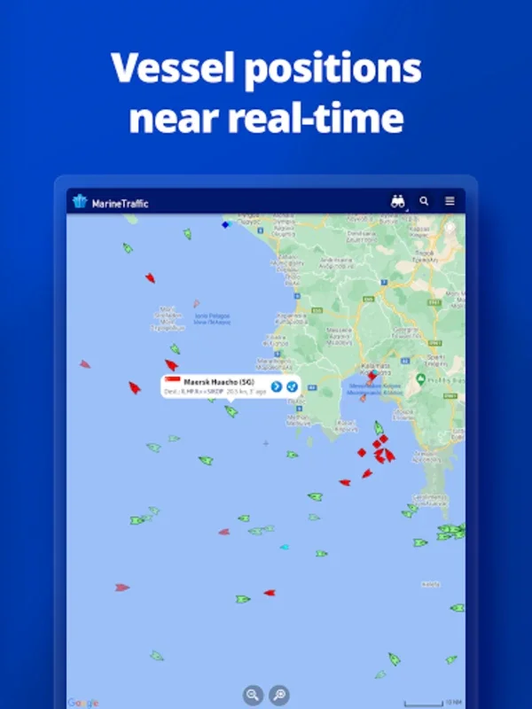
The live map visualization feature is one of the most prominent aspects of MarineTraffic - Ship Tracking. It allows users to see ships, boats, and other vessels in real - time on a global map. This not only provides the exact location of the vessels but also gives a sense of the overall maritime traffic situation. For example, in busy shipping lanes like the Strait of Malacca or the English Channel, one can observe a high concentration of vessels, which is crucial for traffic management and safety.
Wind Forecasts
Weather plays a vital role in maritime operations. MarineTraffic - Ship Tracking offers wind forecasts for the next 48 hours integrated into the map interface. This enables ship captains and operators to plan their routes more effectively, taking into account the wind conditions. For instance, if a ship is sailing with a large cargo load, it can avoid areas with strong headwinds to save fuel and time.
Animated Playback
The animated playback feature is a valuable tool for analyzing the past movements of vessels. By tracing the course of vessels, users can review their past journeys and patterns. This can be useful for investigating incidents, such as collisions or near - misses, as well as for understanding the typical routes of ships in a particular area. For example, if a ship has deviated from its normal route, the animated playback can help determine the possible reasons, such as avoiding bad weather or following a new shipping lane.
Port Information
MarineTraffic - Ship Tracking provides up - to - date data on over 4,000 ports globally. This includes information on arrivals, departures, current conditions, and estimated times of arrival. Port authorities can use this information to manage the flow of ships in and out of the port more efficiently. For ship owners and operators, it helps in planning their schedules and ensuring timely arrivals and departures.
My Fleet
The My Fleet feature allows users to organize and track specific vessels. This is especially useful for shipping companies that have a large number of ships in their fleet. They can easily monitor the location and status of each ship and synchronize their selections across multiple devices. This ensures that all relevant parties, such as the operations team and the management, are on the same page regarding the fleet's movements.
Extensive Photo Database
The software also has an extensive photo database with over 4.5 million maritime photographs. These photos feature ships, lighthouses, and other maritime elements. This can be a great resource for maritime enthusiasts, historians, and researchers. For example, they can study the evolution of ship designs over time or the architecture of different lighthouses around the world.
Advanced Features for Enhanced Maritime Analysis
Augmented Reality
MarineTraffic - Ship Tracking offers an Augmented Reality feature. By pointing the device's camera towards the horizon, users can gather detailed information about nearby vessels. This provides a more immersive and real - time experience of the maritime environment. For example, if a user is on a ship or at a port, they can quickly identify the vessels around them and access relevant information such as their name, type, and destination.
Premium Resources for Subscribers
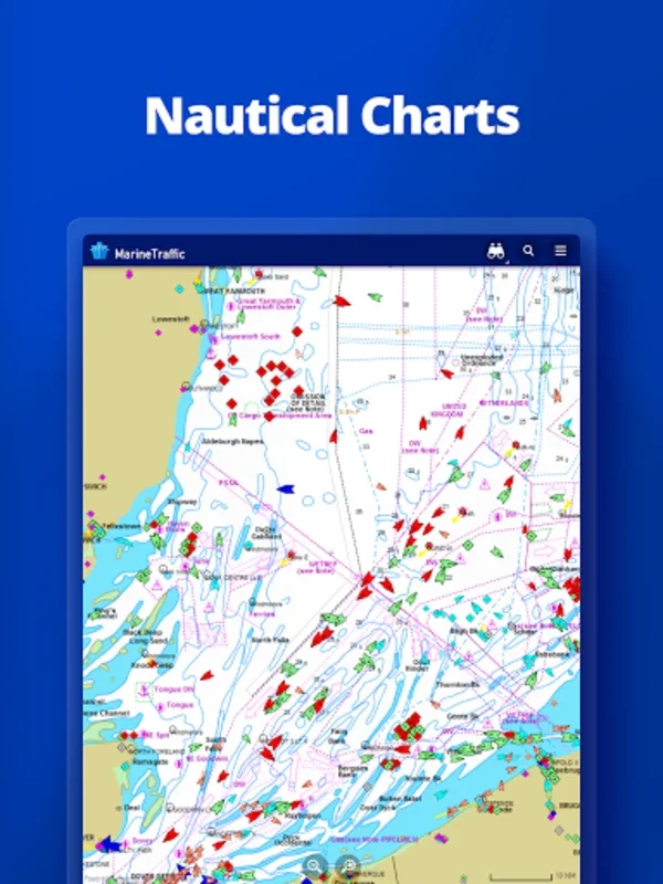
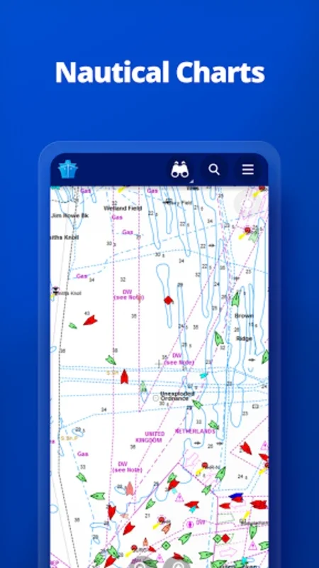
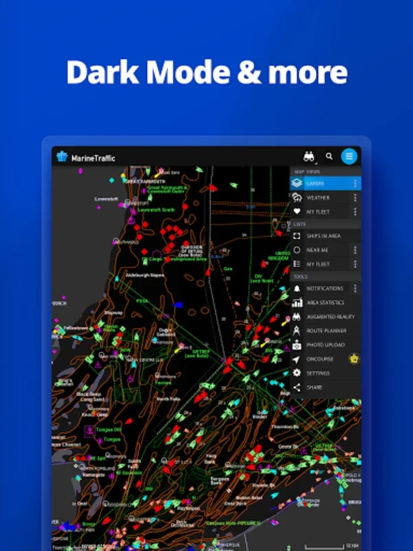
Subscribers to MarineTraffic - Ship Tracking can access premium resources. These include nautical charts, detailed meteorological mapping, density maps, and satellite - provided AIS data. Nautical charts are essential for safe navigation, while detailed meteorological mapping helps in better weather forecasting and route planning. Density maps can show areas of high and low maritime traffic, which is useful for avoiding congested areas. Satellite - provided AIS data offers a more comprehensive view of the maritime situation, especially in areas with limited terrestrial AIS coverage.
Importance of AIS Coverage
To fully utilize MarineTraffic - Ship Tracking, it is important to ensure that the region of interest has robust AIS coverage. AIS is the backbone of the software's ship - tracking capabilities. In areas with good AIS coverage, the software can provide accurate and up - to - date information on ship positions and movements. However, in areas with poor AIS coverage, the data may be incomplete or inaccurate. Therefore, it is crucial for users to be aware of the AIS coverage in their area of interest.
MarineTraffic - Ship Tracking and the Maritime Community
MarineTraffic - Ship Tracking connects users to an international community dedicated to sharing tracking data and insights. This community includes ship owners, operators, port authorities, and maritime enthusiasts. By sharing data and insights, the community can improve situational awareness at sea. For example, if a ship encounters an unexpected situation, such as a floating object or a change in weather conditions, it can share this information with other members of the community, who can then take appropriate action to avoid potential risks.
Conclusion
MarineTraffic - Ship Tracking is a powerful and versatile software that offers a wide range of features for ship tracking and maritime analysis. Whether you are a professional in the maritime industry or an enthusiast, this software can provide you with valuable information and insights into the world of ships and the oceans. With its continuous development and improvement, it is likely to remain a leading tool in the maritime domain for years to come.